This map plots the settings and references in The Scarlet Letter
To start exploring, click a red pin


The Scarlet Letter is set in 1640s Boston, the present-day capital of Massachusetts. A decade on from its initial settlement by Puritan colonists, it bore little resemblance to the metropolis of today.
Located on the Shawmut Peninsula, the town was surrounded by dense forest, above which rose three tall hills. The inhabitable areas were hemmed in by marshes and mudflats. In 1640, Boston was home to 1,200 colonists who clustered about the southern shores in simple wooden houses. Their lives were structured on the Puritan ideals that had informed their migration, and all strived to make the “City upon a Hill” the model of the perfect communion with God that its founder, John Winthrop, had envisioned. Though this led to an efficient, well-regulated society, citizens were subject to harsh laws covering the minutest details of their moral and social activities. Failure to abide by Puritan mores met with severe punishment, and Boston was the scene of the Antinomian Controversy and the persecution of Quakers.

 First Settlement of Boston - Credit:
Robert Sears
 View of Boston Common (c.1750) - Credit:
Hannah Otis
 View of Salem from Gallows Hill (1818) - Credit:
Alvan Fisher
The introductory essay, ‘The Custom-House,’ is set in mid-nineteenth century Salem.
Salem lies on America’s east coast in Essex County, Massachusetts, bordered to the north by the Danvers River and to the south by Marblehead and the Forest River area. First colonized by Europeans in 1626, Salem's seaboard location made it an ideal center for maritime activity, and by the end of the eighteenth century it had become the richest port in America. Political machinations and military clashes, however, brought an abrupt halt to this prosperity, and by Hawthorne's time Salem was in a state of flux. While the past successes of its sea merchants had bequeathed it a good deal of fine architecture, the wharves and harbors were slipping into forlorn disuse; the manufacturing industries that would bring future wealth to the city had not yet been fully established. Mid-nineteenth Salem teetered between nostalgic pride and uncomfortable self-doubt, further colored by the historic atrocities — particularly the witch trials of 1692 — that still loomed large in the consciousness of its inhabitants.

A custom house is a government office responsible for collecting customs and for clearing ships for entry and exit of the port. Salem's version was built in imposing Federalist style in 1819, facing the Derby Wharf at the juncture of Derby and Orange Streets.
 Salem Custom-House (c.1906) - Credit:
Detroit Publishing Co
Hawthorne was the custom house surveyor from 1846 after being nominated by James K. Polk, the newly-elected Democratic President. (It was established practice for a government to fill its departments with its own supporters and the Democratic Hawthorne sought benefit from this kind of political patronage throughout his career.) His post was supposed to last for four years but was terminated after three when the Whig leader, Zachary Taylor, became President.
Explore the custom house and its neighborhood using the street-view map below.
 The Old Manse - Credit:
Detroit Publishing Co.
The Old Manse is a handsome Georgian house located on Monument Street, Concord, Massachusetts by the Concord River. Built in 1770 by the Reverend William Emerson, its register of inhabitants resembles a student's reading list for a nineteenth-century American literature course. The transcendentalist Ralph Waldo Emerson, grandson of the reverend, lived here whilst writing Nature (1836); Nathaniel Hawthorne moved in with his bride, Sophia née Peabody, on 9th July, 1842; and Henry David Thoreau created a vegetable garden as a wedding present for the couple.
During his residency, Hawthorne published roughly twenty sketches and tales, later collected in Mosses from an Old Manse (1846). The essay he refers to here heads the collection.
 Entrance to the Old Manse - Credit:
Library of Congress Historic American Buildings Survey
 Salem as it was in 1854 - Credit:
John William Hill
Salem, the county seat of Essex, Massachusetts, was settled in 1626 by Puritan pilgrims who named it for the Hebrew word for peace, shalom. Ideally located on the edge of Massachusetts Bay, by the end of the eighteenth century it had become the wealthiest trading port in America. Salem merchants dealt in luxuries, importing lacquered furniture, indigo, textiles and spices from the Far East, and molasses from the West Indies for the highly lucrative purpose of manufacturing rum. Export ships carried dried fish, lumber, cotton, tobacco and beef all around the world. Salem’s maritime fortunes were brought an abrupt halt by the Embargo Act of 1807, which vetoed any vessel traveling to a foreign port, and by the War of 1812 against the British. During the nineteenth century, it increasingly turned to industry as a means of generating wealth and, as the tanneries, shoe manufacturers and cotton companies gained in stature, the wharves slipped into the decline Hawthorne describes here.

 Old Derby Wharf and Salem Harbor - Credit:
Boston Public Library
 'Maggie Louisa' of Yarmouth, Nova Scotia (1866) - Credit:
McCord Museum
Nova Scotia is a maritime province lying on Canada’s eastern coast. It was first settled in 1605 by French colonists and boat-building formed the backbone of its industry from the outset. In Hawthorne’s time, it boasted the third largest ocean-going fleet in the world. Schooners — relatively small and speedy vessels with fore-and-aft rigging — were Nova Scotia’s mainstay, conveying goods down the length of the Atlantic Seaboard and into the Caribbean.

 An aerial view of contemporary Nova Scotia - Credit:
Jvienneau
Visit an online archive of photographs and historical documents relating to Nova Scotia schooners here.

 Derby House, Derby Street - Credit:
Fletcher6
Derby Street — which is named after Elias Hasket Derby, the famous shipping magnate to whom Hawthorne alludes earlier — runs parallel to Salem Harbor. At the height of the city’s maritime powers, as many as 30 wharves jutted out from its length. It was on Derby Street that the custom house was situated, across from the wharf that also took its name from Salem's merchant “king.”
 London's West India Docks at Wapping (1810) - Credit:
Thomas Rowlandson & Charles Pugin
Wapping is the part of London that houses the dockside area. It has a long seafaring history: Sir Walter Raleigh equipped his ship there for his voyage to Guyana and James Cook lived there as a young boy. By Hawthorne’s time, it enjoyed a monopoly, being the place at which ships carrying imports from abroad were obliged to unload by the East India Company.
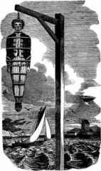
Though Hawthorne uses Wapping generically to refer to any dockside area, it is interesting to note that it, like the port of Salem, was a major site of public punishment. Execution Dock was the stage where assorted buccaneers, mutineers and smugglers were hung for over 400 years up until 1830. The scaffold was positioned right above the water, and the bodies weren’t cut down until three tides had washed over them.
 John Hathorne's Grave - Credit:
Dana Huff
Charter Street Cemetery, also known as the Old Burying Point, is the oldest recorded cemetery in Salem and the second oldest in the United States. It was first established in 1637; John Hathorne was interred there in 1717. Time has so eroded his grave that it is now embedded in concrete to preserve it against further deterioration, but it remains one of the most famous the cemetery contains and is a mainstay of Salem’s enduringly popular witch tours. The winged skull that hovers over the epitaph may look like a grisly indictment but was in fact a ubiquitous symbol in early New England, representing at once the transitory nature of human life and the possibility of transcendence. The “stain” Hawthorne alludes to has been visually realized in recent years through the erection of Salem Witch Trials Tercentenary Memorial. Empty seats, each inscribed with the name of an accused witch together with the date and method of execution, are ranged in a circle. As repositories of infernal influence, the victims were of course not afforded a proper burial at the time of their death.
Explore the Salem Witch Trials Tercentenary Memorial with professional tour guide Mollie Stewart.
 The old burying point - Credit:
Kent Kanouse
 Aerial view of Fort Ticonderoga - Credit:
Fort Ticonderoga Museum
Fort Ticonderoga was built by the French and Canadians between 1754-7 in New York State at the intersection of the water highway that connected New France and the British American territories. Because of its position, it was of vital strategic importance, serving as the key to the entire continent. It was captured by the British in 1759 at the Battle of Ticonderoga and then by the Americans in 1775, making it the first American victory in the Revolutionary War. The fort ceased to be of military value after the war and gradually fell into ruin. It was restored in the early twentieth century and now serves as a popular tourist attraction. Find out more about it here.
 Map of the Niagara Frontier (1869) - Credit:
Benson J. Lossing
The Niagara frontier, part of Western New York State, encompasses the area to the east of the Niagara River and south of Lake Erie.
 Niagara frontier - Credit:
Lone Primate
 Boating on the Assabet - Credit:
Bill Comstock
 The Assabet River at Concord - Credit:
Barbara L. Slavin
The Assabet River is a 20-mile stretch of water than begins in the swamps of Westborough and ends in Concord, where it merges with the Sudbury River. Hawthorne loved this wooded, romantic area, declaring in ‘The Old Manse’ that “a more lovely stream than this... has never flowed on earth.” He often took boats out upon it with Channing and Thoreau for summer fishing expeditions; during the winter, its frozen surface was perfect for their ice-skating jaunts.
 Replica of Thoreau's cabin at Walden, complete with his statue - Credit:
Lorianne DiSabato
Thoreau’s commitment to Transcendentalism led him to live for two years in a cabin he built himself in the woods at Walden Pond near Concord. Eschewing human companionship and material comforts as far as possible, he sought to live frugally and self-sufficiently, believing that to do so would afford him a keen, elemental understanding of nature, society and his own place within each. Whilst there, he recorded his experiences in his most famous work, Walden (1854). Listen to a reading by Gord Mackenzie below.
 Walden Pond - Credit:
Girish Kulkarni and Nishita Desai
This is a reference to an incident occurring in 1776 at the start of the Revolutionary War. Having been victorious in the Battles of Lexington and Concord, the British forces held control of Boston but found themselves closely besieged by George Washington’s Patriots. The future first president ordered his artillery commander to bring a cannon to Dorchester Heights, which he duly did, dragging the hefty ordnance across miles of snow-covered, roadless ground. The Patriots worked secretly through the night to establish their weaponry and, when the British awoke to see the entire of Boston essentially under the domination of their enemies, they and their supporters had no choice but to evacuate. Halifax, Nova Scotia, was the place to which they fled.
 British forces being compelled to evacuate (1885) - Credit:
Bernhard Gillam
 Boston Merchants' Exchange - Credit:
Boston Public Library
Change is an abbreviation for the Boston Merchants’ Exchange, the center for all the city’s financial and business activities. During Hawthorne's time, this was located on State Street in a building designed by Isaiah Rogers (1800-69).
 View of the Merchants Exchange, State Street and adjacent buildings, 1842 - Credit:
Boston Public Library
 Saint Peter's Episcopal Church graveyard - Credit:
Melissa Doroquez
Saint Peter’s Episcopal Church was established in 1733, shortly after permission to found non-Congregationalist churches had been granted. In 1833, the original wooden edifice was demolished to make way for a stone building. The new foundations came in the way of a burial ground, the digging of which unearthed the remains of former worshippers. This grisly spectacle is recounted in an article that appeared in The Salem Observer on 8th June, 1833, in which the corpse of Jonathan Pue is singled out for a detailed description. The piece, undoubtedly Hawthorne's source, can be read here.
 Saint Peter's Episcopal Church - Credit:
Melissa Doroquez

Boston Gaol, the first institution of its kind for the Massachusetts Bay colony, was established in 1635. It was located in the square at the center of Cornhill (present-day Washington Street), Treamont (Tremont) Street, Prison Lane (Court Street) and School Street, and played host to Quakers, witches and the usual assortment of criminals until its closure in 1822.
 Old Town Gaol, Market-Place, Boston - Credit:
William Brand
Isaac Johnson (1601-30) was an early addition to Massachusetts Bay Colony, arriving along with John Winthrop on 12th June 1630. He was among the founders of the first church at Charlestown and oversaw the move to settle what would become Boston (then Shawmut). He also has the unfortunate legacy of being the colony’s earliest casualty: on 30th September, just three and a half months after planting feet on American soil, he died. He was buried in his vegetable garden, marking the beginning of what is now King’s Chapel Burying Ground, a site which for two centuries existed cheek-by-jowl with the gaol at the juncture of Tremont and School Streets.
 King's Chapel Burying Ground (c.1898) - Credit:
BPL Department
 Court Street (Prison Lane) as it appeared in Hawthorne's time - Credit:
Boston Public Library
 The type of scaffold used for executions - Credit:
Okinawa Soba
 Hester on the scaffold in the 1926 silent film version of The Scarlet Letter - Credit:
Victor Seastrom
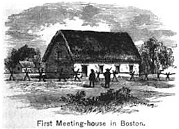
Boston’s first church was founded in 1630 by the original wave of Puritan settlers. From 1632, its members congregated in the meeting house near present-day State Street, a modest building with wattle-and-daub-covered stone walls and a thatched roof. It has been demolished, reconstructed and moved many times over the centuries and now stands on 66 Marlborough Street, a good deal grander than in its original form. You can visit its website here and read about its history here.
This city is later specified as Amsterdam, the capital city of the Netherlands. Amsterdam had, as result of the autonomy it gained after its war with religiously-restrictive Spain, defined itself as a place where people were free to worship as they pleased. As a result, it attracted Puritans fleeing England to escape the authority of the bishops during 1608. These renegades would ultimately leave Europe altogether to set up new religious colonies in America.
 Amsterdam is renowned for its canal system - Credit:
Gerrit Adriaensz. Berckheyde
 An aerial view of present-day Oxford - Credit:
SirMetal
Oxford is a small city in the south-east of England renowned for its world-class university. With its quadrangled and gargoyle-studded colleges, twisting alleyways and fine churches dating from every architectural period, it is often known as the city of dreaming spires.
 Present-day Spring Lane - Credit:
Josh Graciano
Spring Lane is so-called because it was the site of ”the Great Spring of Boston” which provided fresh, clean water to the settlers (and their cattle) for over two centuries. This once-central vein of Boston is today a narrow alleyway which links Washington and Devonshire Streets in the Downtown area.
 Cattle trough - Credit:
Jessica Mulley